


2014 Cross 7km Brumath

staubalex
Gebruiker
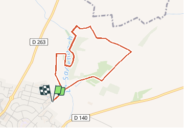

Lengte
6,9 km

Max. hoogte
183 m

Positief hoogteverschil
90 m
Km-Effort
8,1 km

Min. hoogte
151 m

Negatief hoogteverschil
90 m
Boucle
Ja
Datum van aanmaak :
2014-12-10 00:00:00.0
Laatste wijziging :
2014-12-10 00:00:00.0
32m
Moeilijkheid : Gemakkelijk

Gratisgps-wandelapplicatie
 SityTrail
IGN / Geografische instituten
SityTrail Plus
De wereld gaat voor u open
Over ons
Tocht Mountainbike van 6,9 km beschikbaar op Grand Est, Bas-Rhin, Brumath. Deze tocht wordt voorgesteld door staubalex.
Plaatsbepaling
Land:
France
Regio :
Grand Est
Departement/Provincie :
Bas-Rhin
Gemeente :
Brumath
Locatie:
Unknown
Vertrek:(Dec)
Vertrek:(UTM)
405993 ; 5399026 (32U) N.
Opmerkingen