


chagey

jacthiry
Gebruiker
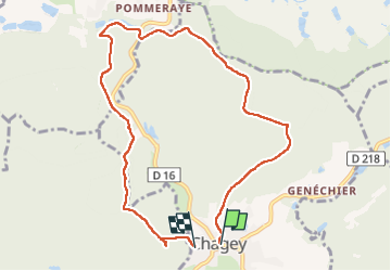

Lengte
8,9 km

Max. hoogte
451 m

Positief hoogteverschil
230 m
Km-Effort
11,9 km

Min. hoogte
346 m

Negatief hoogteverschil
226 m
Boucle
Neen
Datum van aanmaak :
2023-01-26 12:49:03.707
Laatste wijziging :
2023-01-26 15:32:27.249
2h42
Moeilijkheid : Medium

Gratisgps-wandelapplicatie
 SityTrail
IGN / Geografische instituten
SityTrail Plus
De wereld gaat voor u open
Over ons
Tocht Stappen van 8,9 km beschikbaar op Bourgondië-Franche-Comté, Haute-Saône, Chagey. Deze tocht wordt voorgesteld door jacthiry.
Plaatsbepaling
Land:
France
Regio :
Bourgondië-Franche-Comté
Departement/Provincie :
Haute-Saône
Gemeente :
Chagey
Locatie:
Unknown
Vertrek:(Dec)
Vertrek:(UTM)
329625 ; 5275703 (32T) N.
Opmerkingen