Tocht Stappen Chauny - 3fontaine - Photo
 Ludovic Fort
Ludovic Fort

Gebruiker

© OpenStreetMap contributors
Lengte
Lengte
20 km
Max. hoogte
Max. hoogte
143 m
Positief hoogteverschil
254 m
Km-Effort
Km-Effort  
23 km
Min. hoogte
Min. hoogte
52 m
Negatief hoogteverschil
254 m
Boucle
Boucle
Ja
Datum van aanmaak :
2023-02-04 10:37:29.313
Laatste wijziging :
2023-02-04 15:36:25.868

(0 Bericht)

Stappen
Stappen
4h18
Moeilijkheid : Medium

Scan deze QR-code om de tocht te openen in de SityTrail-applicatie

Gratisgps-wandelapplicatie

Logo SityTrail SityTrail

IGN / Geografische instituten

SityTrail uit de App Store downloaden SityTrail uit Google Play downloaden

Logo SityTrail SityTrail World

De wereld gaat voor u open

SityTrail uit de App Store downloaden SityTrail uit Google Play downloaden SityTrail op Huawei AppGallery downloaden

Over ons

Tocht Stappen van 20 km beschikbaar op Hauts-de-France, Aisne, Chauny. Deze tocht wordt voorgesteld door Ludovic Fort.

Beschrijving

trois Fontaines

Hoogteprofiel

Plaatsbepaling

Land:
France
Regio :
Hauts-de-France
Departement/Provincie :
Aisne
Gemeente :
Chauny
Locatie:
Unknown
Vertrek:(UTM)
514150 ; 5497711 (31U) N.

Wandeltochten in de omgeving

Tocht Te voet Caumont - Caumont - Photo
Te voet
fitz2014

Te voet

Medium
(1)
Caumont, Hauts-de-France, Aisne, France
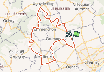
18 km | 21 km-effort
4h 47min
Ja
Tocht Stappen Villequier-Aumont - villequier aumont - Photo
Stappen
alainwald

Stappen

Heel gemakkelijk
Villequier-Aumont, Hauts-de-France, Aisne, France
16,4 km | 19,7 km-effort
3h 30min
Ja
Tocht Fiets Chauny - Sur les versants de l'Oise - 55 km - Chauny - Photo
Fiets
tracegps

Fiets

Moeilijk
Chauny, Hauts-de-France, Aisne, France
55 km | 62 km-effort
5h 30min
Ja
Tocht Fiets Chauny - Sur les versants de l'Oise - 27 km - Chauny - Photo
Fiets
tracegps

Fiets

Medium
Chauny, Hauts-de-France, Aisne, France
25 km | 30 km-effort
2h 30min
Ja
Tocht Mountainbike Sinceny - Sortie VTT - Photo
Mountainbike
patweb02

Mountainbike

Heel gemakkelijk
Sinceny, Hauts-de-France, Aisne, France
13,9 km | 14,9 km-effort
1h 0min
Ja
Tocht Andere activiteiten Chauny - Picardie - Ligne 234 - Anizy-Pinon - Chauny - Photo
Andere activiteiten
mich54

Andere activiteiten

Heel gemakkelijk
Chauny, Hauts-de-France, Aisne, France
25 km | 27 km-effort
5min
Neen
Tocht Stappen Villequier-Aumont - Sur les pas de josé - Photo
Stappen
José800

Stappen

Medium
Villequier-Aumont, Hauts-de-France, Aisne, France
9,2 km | 10,4 km-effort
2h 22min
Ja
Tocht 4x4 Chauny - Rando 4L - Photo
4x4
jojo02

4x4

Gemakkelijk
Chauny, Hauts-de-France, Aisne, France
88 km | 102 km-effort
4h 16min
Ja
Tocht Mountainbike Chauny - la frette - Photo
Mountainbike
jojo02

Mountainbike

Gemakkelijk
Chauny, Hauts-de-France, Aisne, France
15,2 km | 16,3 km-effort
53min
Neen


Sluiten
Mijn abonnementen