![](/images/other/stat-length.png)
![Tocht Mountainbike Saujac - Estrabols Tourrens SalvagnacCajarc Liguaire Mas de Mouysset Siau CausseS les fumades La Vayssiere Saujac la balme les baumades borie angle D24 Estrabols - Photo](https://media.geolcdn.com/t/1900/400/ext.pjpeg?maxdim=2&url=https%3A%2F%2Fstatic1.geolcdn.com%2Fsiteimages%2Fupload%2Ffiles%2F1524743154velo.jpg)
Estrabols Tourrens SalvagnacCajarc Liguaire Mas de Mouysset Siau CausseS les fumades La Vayssiere Saujac la balme les baumades borie angle D24 Estrabols
Gerard_Soulie
Gebruiker
![Lengte](/images/other/stat-length.png)
Lengte
28 km
![Max. hoogte](https://static1.geolcdn.com/siteimages/upload/files/1508320355ic_sort_altitude_max_24dp.png)
Max. hoogte
339 m
![Positief hoogteverschil](https://static1.geolcdn.com/siteimages/upload/files/1508320355ic_sort_den_pos_24dp.png)
Positief hoogteverschil
567 m
![Km-Effort](/images/other/stat-length.png)
Km-Effort
36 km
![Min. hoogte](https://static1.geolcdn.com/siteimages/upload/files/1508320355ic_sort_altitude_min_24dp.png)
Min. hoogte
153 m
![Negatief hoogteverschil](https://static1.geolcdn.com/siteimages/upload/files/1508320355ic_sort_den_neg_24dp.png)
Negatief hoogteverschil
568 m
![Boucle](https://static1.geolcdn.com/siteimages/upload/files/16400158638029165_repeat_loop_refresh_sync_direction_icon.png)
Boucle
Ja
Datum van aanmaak :
2014-12-10 00:00:00.0
Laatste wijziging :
2014-12-10 00:00:00.0
![Mountainbike](https://static1.geolcdn.com/sitytour/trail-icons/202.png)
2h59
Moeilijkheid : Medium
![Scan deze QR-code om de tocht te openen in de SityTrail-applicatie](https://capi.geolives.com/qq0zvz2zws4bq2lad0pu/sitytour/trails/354247/qr.png?size=200)
Gratisgps-wandelapplicatie
Over ons
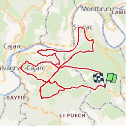
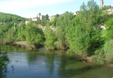
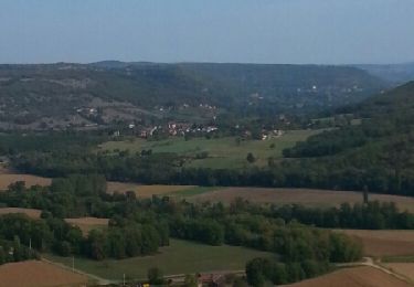
Tocht Mountainbike van 28 km beschikbaar op Occitanië, Aveyron, Saujac. Deze tocht wordt voorgesteld door Gerard_Soulie.
Beschrijving
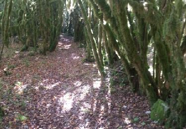
attention remontée de Saujac sur la Causse difficile marcher sur 600 m ne pas descendre à vtt partie sous la falaise
Plaatsbepaling
Land:
France
Regio :
Occitanië
Departement/Provincie :
Aveyron
Gemeente :
Saujac
Locatie:
Unknown
Vertrek:(Dec)
Vertrek:(UTM)
413059 ; 4924076 (31T) N.
Opmerkingen
Wandeltochten in de omgeving
![Tocht Stappen Saujac - Saujac-Bastides et Gorges de l'Aveyron - Photo](https://media.geolcdn.com/t/375/260/ext.jpg?maxdim=2&url=https%3A%2F%2Fmedia.geolcdn.com%2Ff%2Fedce4b0c-20dd-4058-b3e5-09b6cd2f3285.JPG)
![Stappen Stappen](https://static1.geolcdn.com/sitytour/trail-icons/101.png)
Saujac-Bastides et Gorges de l'Aveyron
Stappen
Moeilijk
(1)
Saujac,
Occitanië,
Aveyron,
France
![](/images/other/stat-length.png)
9,7 km | 13 km-effort
2h 56min
![](https://static1.geolcdn.com/siteimages/upload/files/16400158638029165_repeat_loop_refresh_sync_direction_icon.png)
Ja
![Tocht Te voet Sainte-Croix - Balade autour de Sainte-Croix - Circuit 1 - Photo](https://media.geolcdn.com/t/375/260/ext.jpg?maxdim=2&url=https%3A%2F%2Fmedia.geolcdn.com%2Ff%2F84d92542-f3fe-4f66-8d84-4e6ce3f3d406.jpeg)
![Te voet Te voet](https://static1.geolcdn.com/sitytour/trail-icons/100.png)
Balade autour de Sainte-Croix - Circuit 1
Te voet
Gemakkelijk
Sainte-Croix,
Occitanië,
Aveyron,
France
![](/images/other/stat-length.png)
4,2 km | 5,3 km-effort
1h 12min
![](https://static1.geolcdn.com/siteimages/upload/files/16400158638029165_repeat_loop_refresh_sync_direction_icon.png)
Ja
![Tocht Te voet Sainte-Croix - Balade autour de Sainte-Croix - Circuit 2 - Photo](https://media.geolcdn.com/t/375/260/ext.jpg?maxdim=2&url=https%3A%2F%2Fmedia.geolcdn.com%2Ff%2F84d92542-f3fe-4f66-8d84-4e6ce3f3d406.jpeg)
![Te voet Te voet](https://static1.geolcdn.com/sitytour/trail-icons/100.png)
Balade autour de Sainte-Croix - Circuit 2
Te voet
Gemakkelijk
Sainte-Croix,
Occitanië,
Aveyron,
France
![](/images/other/stat-length.png)
4,9 km | 6,2 km-effort
1h 24min
![](https://static1.geolcdn.com/siteimages/upload/files/16400158638029165_repeat_loop_refresh_sync_direction_icon.png)
Neen
![Tocht Te voet Sainte-Croix - Balade autour de Sainte-Croix - Circuit 3 - Photo](https://media.geolcdn.com/t/375/260/ext.jpg?maxdim=2&url=https%3A%2F%2Fmedia.geolcdn.com%2Ff%2F84d92542-f3fe-4f66-8d84-4e6ce3f3d406.jpeg)
![Te voet Te voet](https://static1.geolcdn.com/sitytour/trail-icons/100.png)
Balade autour de Sainte-Croix - Circuit 3
Te voet
Gemakkelijk
Sainte-Croix,
Occitanië,
Aveyron,
France
![](/images/other/stat-length.png)
6,5 km | 8,1 km-effort
1h 50min
![](https://static1.geolcdn.com/siteimages/upload/files/16400158638029165_repeat_loop_refresh_sync_direction_icon.png)
Ja
![Tocht Te voet Sainte-Croix - Circuit des 3 clochers - Photo](https://media.geolcdn.com/t/375/260/ext.jpg?maxdim=2&url=https%3A%2F%2Fmedia.geolcdn.com%2Ff%2F84d92542-f3fe-4f66-8d84-4e6ce3f3d406.jpeg)
![Te voet Te voet](https://static1.geolcdn.com/sitytour/trail-icons/100.png)
Circuit des 3 clochers
Te voet
Gemakkelijk
Sainte-Croix,
Occitanië,
Aveyron,
France
![](/images/other/stat-length.png)
13,9 km | 17,4 km-effort
3h 57min
![](https://static1.geolcdn.com/siteimages/upload/files/16400158638029165_repeat_loop_refresh_sync_direction_icon.png)
Ja
![Tocht Stappen Cajarc - Le Lot à Cajarc - Photo](https://media.geolcdn.com/t/375/260/ext.jpg?maxdim=2&url=https%3A%2F%2Fmedia.geolcdn.com%2Ff%2F4edfb6ba-77c2-4b7c-8112-ab3fdf722c8d.jpg)
![Stappen Stappen](https://static1.geolcdn.com/sitytour/trail-icons/101.png)
![Tocht Stappen Cajarc - CC_Velay_DA_13_Cajarc_Bach_20080504 - Photo](https://media.geolcdn.com/t/375/260/ext.jpg?maxdim=2&url=https%3A%2F%2Fmedia.geolcdn.com%2Ff%2F28b3b446-d6cb-478f-8532-de2b5c17785c.JPG)
![Stappen Stappen](https://static1.geolcdn.com/sitytour/trail-icons/101.png)
CC_Velay_DA_13_Cajarc_Bach_20080504
Stappen
Medium
Cajarc,
Occitanië,
Lot,
France
![](/images/other/stat-length.png)
32 km | 40 km-effort
7h 20min
![](https://static1.geolcdn.com/siteimages/upload/files/16400158638029165_repeat_loop_refresh_sync_direction_icon.png)
Neen
![Tocht Mountainbike La Capelle-Balaguier - la capelle maroule puyjourdes loule anglars les buis lacapelle - Photo](https://media.geolcdn.com/t/375/260/ext.jpg?maxdim=2&url=https%3A%2F%2Fservices.sitytrail.com%2FGeolivesWS%2FDownloadMedia.ashx%3FTrailID%3D357254%26Media%3Dfix__20141026113853.jpg)
![Mountainbike Mountainbike](https://static1.geolcdn.com/sitytour/trail-icons/202.png)
la capelle maroule puyjourdes loule anglars les buis lacapelle
Mountainbike
Medium
La Capelle-Balaguier,
Occitanië,
Aveyron,
France
![](/images/other/stat-length.png)
31 km | 40 km-effort
2h 52min
![](https://static1.geolcdn.com/siteimages/upload/files/16400158638029165_repeat_loop_refresh_sync_direction_icon.png)
Ja
![Tocht Mountainbike La Capelle-Balaguier - la capelle anglars estrabols borieangle croix belge saut mounine trep et retour lac - Photo](https://media.geolcdn.com/t/375/260/ext.jpg?maxdim=2&url=https%3A%2F%2Fservices.sitytrail.com%2FGeolivesWS%2FDownloadMedia.ashx%3FTrailID%3D349148%26Media%3Dfix__20140928112930.jpg)
![Mountainbike Mountainbike](https://static1.geolcdn.com/sitytour/trail-icons/202.png)
la capelle anglars estrabols borieangle croix belge saut mounine trep et reto...
Mountainbike
Medium
La Capelle-Balaguier,
Occitanië,
Aveyron,
France
![](/images/other/stat-length.png)
32 km | 40 km-effort
3h 8min
![](https://static1.geolcdn.com/siteimages/upload/files/16400158638029165_repeat_loop_refresh_sync_direction_icon.png)
Ja