


Collège

charpe
Gebruiker
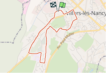

Lengte
4,1 km

Max. hoogte
343 m

Positief hoogteverschil
95 m
Km-Effort
5,4 km

Min. hoogte
243 m

Negatief hoogteverschil
99 m
Boucle
Ja
Datum van aanmaak :
2023-02-10 14:16:50.0
Laatste wijziging :
2023-02-10 15:16:10.106
59m
Moeilijkheid : Gemakkelijk

Gratisgps-wandelapplicatie
 SityTrail
IGN / Geografische instituten
SityTrail Plus
De wereld gaat voor u open
Over ons
Tocht Stappen van 4,1 km beschikbaar op Grand Est, Meurthe-et-Moselle, Villers-lès-Nancy. Deze tocht wordt voorgesteld door charpe.
Plaatsbepaling
Land:
France
Regio :
Grand Est
Departement/Provincie :
Meurthe-et-Moselle
Gemeente :
Villers-lès-Nancy
Locatie:
Unknown
Vertrek:(Dec)
Vertrek:(UTM)
289862 ; 5395084 (32U) N.
Opmerkingen