


exp_12 Feb 2023 at 18-21-43.gpx

Tourisme Equestre Alsace
Promouvoir le Tourisme Equestre en Alsace GUIDE+
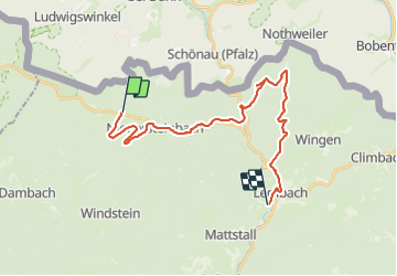

Lengte
23 km

Max. hoogte
385 m

Positief hoogteverschil
458 m
Km-Effort
30 km

Min. hoogte
190 m

Negatief hoogteverschil
495 m
Boucle
Neen
Datum van aanmaak :
2023-02-13 18:29:39.504
Laatste wijziging :
2023-07-10 14:28:10.049
0m
Moeilijkheid : Medium

Gratisgps-wandelapplicatie
 SityTrail
IGN / Geografische instituten
SityTrail Plus
De wereld gaat voor u open
Over ons
Tocht Huifkarwandeling van 23 km beschikbaar op Grand Est, Bas-Rhin, Obersteinbach. Deze tocht wordt voorgesteld door Tourisme Equestre Alsace.
Foto's


Plaatsbepaling
Land:
France
Regio :
Grand Est
Departement/Provincie :
Bas-Rhin
Gemeente :
Obersteinbach
Locatie:
Unknown
Vertrek:(Dec)
Vertrek:(UTM)
404368 ; 5432343 (32U) N.
Opmerkingen