


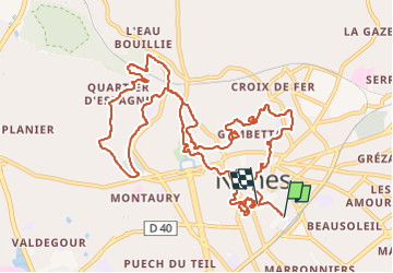
Urban Trail de Nîmes

Pascal84
Gebruiker

Lengte
14,9 km

Max. hoogte
114 m

Positief hoogteverschil
267 m
Km-Effort
18,4 km

Min. hoogte
41 m

Negatief hoogteverschil
263 m
Boucle
Neen
Datum van aanmaak :
2023-02-19 07:58:19.674
Laatste wijziging :
2023-02-19 11:26:25.031
1h59
Moeilijkheid : Medium

Gratisgps-wandelapplicatie
 SityTrail
IGN / Geografische instituten
SityTrail Plus
De wereld gaat voor u open
Over ons
Tocht Lopen van 14,9 km beschikbaar op Occitanië, Gard, Nîmes. Deze tocht wordt voorgesteld door Pascal84.
Plaatsbepaling
Land:
France
Regio :
Occitanië
Departement/Provincie :
Gard
Gemeente :
Nîmes
Locatie:
Unknown
Vertrek:(Dec)
Vertrek:(UTM)
609754 ; 4854249 (31T) N.
Opmerkingen