


Boucles Vosges

adamfv
Gebruiker
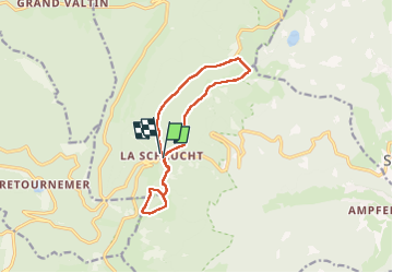

Lengte
11,5 km

Max. hoogte
1281 m

Positief hoogteverschil
329 m
Km-Effort
15,9 km

Min. hoogte
1132 m

Negatief hoogteverschil
339 m
Boucle
Ja
Datum van aanmaak :
2023-02-25 10:33:12.0
Laatste wijziging :
2023-02-25 14:46:37.166
3h18
Moeilijkheid : Gemakkelijk

Gratisgps-wandelapplicatie
 SityTrail
IGN / Geografische instituten
SityTrail Plus
De wereld gaat voor u open
Over ons
Tocht Stappen van 11,5 km beschikbaar op Grand Est, Vogezen, Le Valtin. Deze tocht wordt voorgesteld door adamfv.
Plaatsbepaling
Land:
France
Regio :
Grand Est
Departement/Provincie :
Vogezen
Gemeente :
Le Valtin
Locatie:
Unknown
Vertrek:(Dec)
Vertrek:(UTM)
352705 ; 5325254 (32U) N.
Opmerkingen