


Balazuc Les Louanes

pb07
Gebruiker
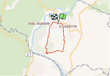

Lengte
4,5 km

Max. hoogte
196 m

Positief hoogteverschil
92 m
Km-Effort
5,7 km

Min. hoogte
131 m

Negatief hoogteverschil
93 m
Boucle
Ja
Datum van aanmaak :
2023-02-25 13:24:15.693
Laatste wijziging :
2023-02-25 15:32:47.324
1h28
Moeilijkheid : Gemakkelijk

Gratisgps-wandelapplicatie
 SityTrail
IGN / Geografische instituten
SityTrail Plus
De wereld gaat voor u open
Over ons
Tocht Stappen van 4,5 km beschikbaar op Auvergne-Rhône-Alpes, Ardèche, Balazuc. Deze tocht wordt voorgesteld door pb07.
Plaatsbepaling
Land:
France
Regio :
Auvergne-Rhône-Alpes
Departement/Provincie :
Ardèche
Gemeente :
Balazuc
Locatie:
Unknown
Vertrek:(Dec)
Vertrek:(UTM)
609198 ; 4929007 (31T) N.
Opmerkingen