


Luc 2

bouscaillou
Gebruiker
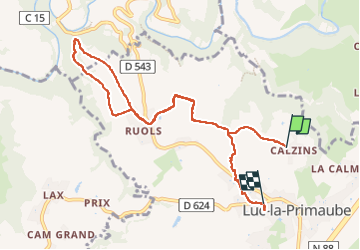

Lengte
9,8 km

Max. hoogte
679 m

Positief hoogteverschil
230 m
Km-Effort
12,8 km

Min. hoogte
577 m

Negatief hoogteverschil
206 m
Boucle
Neen
Datum van aanmaak :
2023-03-13 13:12:33.822
Laatste wijziging :
2023-03-13 15:26:26.985
2h13
Moeilijkheid : Moeilijk

Gratisgps-wandelapplicatie
 SityTrail
IGN / Geografische instituten
SityTrail Plus
De wereld gaat voor u open
Over ons
Tocht Stappen van 9,8 km beschikbaar op Occitanië, Aveyron, Luc-la-Primaube. Deze tocht wordt voorgesteld door bouscaillou.
Plaatsbepaling
Land:
France
Regio :
Occitanië
Departement/Provincie :
Aveyron
Gemeente :
Luc-la-Primaube
Locatie:
Unknown
Vertrek:(Dec)
Vertrek:(UTM)
462739 ; 4907751 (31T) N.
Opmerkingen