


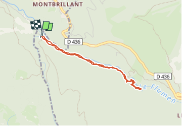
Cascade du Flumen

Chabard
Gebruiker

Lengte
3,7 km

Max. hoogte
549 m

Positief hoogteverschil
84 m
Km-Effort
4,9 km

Min. hoogte
451 m

Negatief hoogteverschil
87 m
Boucle
Ja
Datum van aanmaak :
2023-03-14 10:11:40.0
Laatste wijziging :
2023-03-14 12:15:20.114
1h12
Moeilijkheid : Gemakkelijk

Gratisgps-wandelapplicatie
 SityTrail
IGN / Geografische instituten
SityTrail Plus
De wereld gaat voor u open
Over ons
Tocht Stappen van 3,7 km beschikbaar op Bourgondië-Franche-Comté, Jura, Septmoncel les Molunes. Deze tocht wordt voorgesteld door Chabard.
Beschrijving
Cascade du Flumen
Plaatsbepaling
Land:
France
Regio :
Bourgondië-Franche-Comté
Departement/Provincie :
Jura
Gemeente :
Septmoncel les Molunes
Locatie:
Septmoncel
Vertrek:(Dec)
Vertrek:(UTM)
721468 ; 5138520 (31T) N.
Opmerkingen