


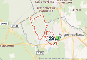
Forges les eaux 7Kms (Dén P 92m)

alain62rando
Gebruiker

Lengte
7 km

Max. hoogte
168 m

Positief hoogteverschil
92 m
Km-Effort
8,2 km

Min. hoogte
134 m

Negatief hoogteverschil
91 m
Boucle
Ja
Datum van aanmaak :
2023-03-18 10:02:43.44
Laatste wijziging :
2023-03-18 10:03:36.093
1h51
Moeilijkheid : Gemakkelijk

Gratisgps-wandelapplicatie
 SityTrail
IGN / Geografische instituten
SityTrail Plus
De wereld gaat voor u open
Over ons
Tocht Stappen van 7 km beschikbaar op Normandië, Seine-Maritime, Forges-les-Eaux. Deze tocht wordt voorgesteld door alain62rando.
Plaatsbepaling
Land:
France
Regio :
Normandië
Departement/Provincie :
Seine-Maritime
Gemeente :
Forges-les-Eaux
Locatie:
Forges-les-Eaux
Vertrek:(Dec)
Vertrek:(UTM)
394072 ; 5496177 (31U) N.
Opmerkingen