


Marsanne, Col de la Ventouse : 2023 Jonquilles

LydiaMich
Gebruiker
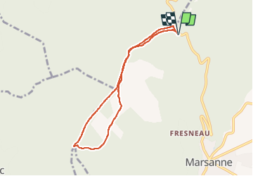

Lengte
7,2 km

Max. hoogte
596 m

Positief hoogteverschil
221 m
Km-Effort
10,2 km

Min. hoogte
491 m

Negatief hoogteverschil
221 m
Boucle
Ja
Datum van aanmaak :
2023-03-20 13:03:06.499
Laatste wijziging :
2023-04-20 06:47:06.91
2h00
Moeilijkheid : Gemakkelijk

Gratisgps-wandelapplicatie
 SityTrail
IGN / Geografische instituten
SityTrail Plus
De wereld gaat voor u open
Over ons
Tocht Stappen van 7,2 km beschikbaar op Auvergne-Rhône-Alpes, Drôme, Marsanne. Deze tocht wordt voorgesteld door LydiaMich .
Plaatsbepaling
Land:
France
Regio :
Auvergne-Rhône-Alpes
Departement/Provincie :
Drôme
Gemeente :
Marsanne
Locatie:
Unknown
Vertrek:(Dec)
Vertrek:(UTM)
647911 ; 4947481 (31T) N.
Opmerkingen