


st Antoine l'abbaye Lac de Chapaize

Gaillardenis
Gebruiker
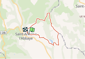

Lengte
7,1 km

Max. hoogte
442 m

Positief hoogteverschil
163 m
Km-Effort
9,2 km

Min. hoogte
349 m

Negatief hoogteverschil
162 m
Boucle
Ja
Datum van aanmaak :
2023-03-21 17:55:45.69
Laatste wijziging :
2023-03-21 17:55:47.22
2h05
Moeilijkheid : Medium

Gratisgps-wandelapplicatie
 SityTrail
IGN / Geografische instituten
SityTrail Plus
De wereld gaat voor u open
Over ons
Tocht Stappen van 7,1 km beschikbaar op Auvergne-Rhône-Alpes, Isère, Saint-Antoine l'Abbaye. Deze tocht wordt voorgesteld door Gaillardenis.
Plaatsbepaling
Land:
France
Regio :
Auvergne-Rhône-Alpes
Departement/Provincie :
Isère
Gemeente :
Saint-Antoine l'Abbaye
Locatie:
Saint-Antoine-l'Abbaye
Vertrek:(Dec)
Vertrek:(UTM)
674374 ; 5004754 (31T) N.
Opmerkingen