Tocht Hybride fiets Fleurines - randonnée Au5v OT Ccpoh halatte - Photo

randonnée Au5v OT Ccpoh halatte

 gilbertdu60
gilbertdu60

Gebruiker

© OpenStreetMap contributors
Lengte
Lengte
30 km
Max. hoogte
Max. hoogte
202 m
Positief hoogteverschil
381 m
Km-Effort
Km-Effort  
35 km
Min. hoogte
Min. hoogte
93 m
Negatief hoogteverschil
381 m
Boucle
Boucle
Ja
Datum van aanmaak :
2023-03-27 07:49:10.064
Laatste wijziging :
2023-04-26 07:43:59.37

(0 Bericht)

Hybride fiets
Hybride fiets
--
Moeilijkheid : Gemakkelijk

Scan deze QR-code om de tocht te openen in de SityTrail-applicatie

Gratisgps-wandelapplicatie

Logo SityTrail SityTrail

IGN / Geografische instituten

SityTrail uit de App Store downloaden SityTrail uit Google Play downloaden

Logo SityTrail SityTrail World

De wereld gaat voor u open

SityTrail uit de App Store downloaden SityTrail uit Google Play downloaden SityTrail op Huawei AppGallery downloaden

Over ons

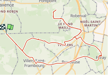
Tocht Hybride fiets van 30 km beschikbaar op Hauts-de-France, Oise, Fleurines. Deze tocht wordt voorgesteld door gilbertdu60.

Beschrijving

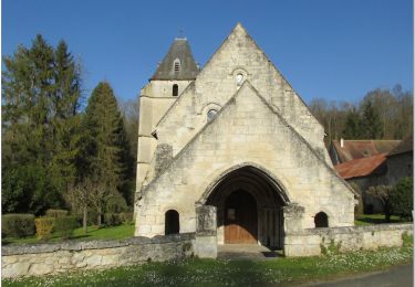
« Entre campagne et forêt domaniale »
départ aux coordonnées GPS 49°16'13.0"N 2°36'59.5"E  
En direction des plateaux, à la lisière des bois et des hautes futaies de la forêt d’Halatte, vers Raray, Yvillers Barbery et Villers St Frambourg.

Hoogteprofiel

Foto's

Plaatsbepaling

Land:
France
Regio :
Hauts-de-France
Departement/Provincie :
Oise
Gemeente :
Fleurines
Locatie:
Unknown
Vertrek:(Dec)
Vertrek:(UTM)
471398 ; 5458366 (31U) N.

Wandeltochten in de omgeving

Tocht Stappen Villers-Saint-Frambourg-Ognon - MR_OGNON (par BALAGNY-sur-AUNETTE)_5.4Km - Photo
Stappen

Stappen

Medium
(3)
Villers-Saint-Frambourg-Ognon, Hauts-de-France, Oise, France
5,4 km | 6,4 km-effort
1h 27min
Ja
Tocht Stappen Beaurepaire - La mare aux oiseaux - Beaurepaire - Photo
Stappen
tracegps

Stappen

Medium
(1)
Beaurepaire, Hauts-de-France, Oise, France
8,4 km | 10,2 km-effort
2h 10min
Ja
Tocht Stappen Fleurines - Fleurines Grand parcours - Photo
Stappen
CC.RIDER

Stappen

Gemakkelijk
(1)
Fleurines, Hauts-de-France, Oise, France
20 km | 24 km-effort
5h 8min
Ja
Tocht Stappen Chamant - Chamant Supermini-rando - Photo
Stappen
CC.RIDER

Stappen

Gemakkelijk
(8)
Chamant, Hauts-de-France, Oise, France
8 km | 9,3 km-effort
2h 7min
Ja
Tocht Stappen Pontpoint - Mont Pagnotte Grand parcours - Photo
Stappen
CC.RIDER

Stappen

Medium
(2)
Pontpoint, Hauts-de-France, Oise, France
16,6 km | 22 km-effort
4h 36min
Ja
Tocht Fietstoerisme Pont-Sainte-Maxence - sortie AU5v Pentecôte 2022 - Photo
Fietstoerisme
gilbertdu60

Fietstoerisme

Gemakkelijk
Pont-Sainte-Maxence, Hauts-de-France, Oise, France
26 km | 29 km-effort
Onbekend
Ja
Tocht Te voet Pont-Sainte-Maxence - balade pedestre 11 avril 2022 - Photo
Te voet
gilbertdu60

Te voet

Gemakkelijk
Pont-Sainte-Maxence, Hauts-de-France, Oise, France
7,2 km | 9,1 km-effort
2h 4min
Ja
Tocht Elektrische fiets Pont-Sainte-Maxence - balade printanière du 23 mars - Photo
Elektrische fiets
gilbertdu60

Elektrische fiets

Gemakkelijk
Pont-Sainte-Maxence, Hauts-de-France, Oise, France
22 km | 26 km-effort
2h 14min
Ja
Tocht Elektrische fiets Pont-Sainte-Maxence - sortie 18 janvier 22 - Photo
Elektrische fiets
gilbertdu60

Elektrische fiets

Gemakkelijk
Pont-Sainte-Maxence, Hauts-de-France, Oise, France
23 km | 27 km-effort
2h 4min
Ja


Sluiten
Mijn abonnementen