Tocht Stappen Utelle - Utelle, Brec d'Utelle - Photo
 GrouGary
GrouGary

Gebruiker

© OpenStreetMap contributors
Lengte
Lengte
11,2 km
Max. hoogte
Max. hoogte
1570 m
Positief hoogteverschil
809 m
Km-Effort
Km-Effort  
22 km
Min. hoogte
Min. hoogte
812 m
Negatief hoogteverschil
809 m
Boucle
Boucle
Ja
Datum van aanmaak :
2023-03-28 06:56:08.626
Laatste wijziging :
2024-04-06 11:58:50.015

(1 Bericht)

Stappen
Stappen
4h59
Moeilijkheid : Zeer moeilijk

Scan deze QR-code om de tocht te openen in de SityTrail-applicatie

Gratisgps-wandelapplicatie

Logo SityTrail SityTrail

IGN / Geografische instituten

SityTrail uit de App Store downloaden SityTrail uit Google Play downloaden

Logo SityTrail SityTrail Plus

De wereld gaat voor u open

SityTrail uit de App Store downloaden SityTrail uit Google Play downloaden SityTrail op Huawei AppGallery downloaden

Over ons

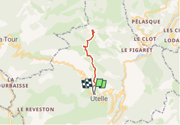
Tocht Stappen van 11,2 km beschikbaar op Provence-Alpes-Côte d'Azur, Alpes-Maritimes, Utelle. Deze tocht wordt voorgesteld door GrouGary.

Beschrijving

Un A/R empruntant le GR5, avec de superbes vues en balcons sur le côté "Tinée" ou le côté "Vésubie" ; Et le Mercantour enneigé visible depuis l'Argentera plus au Nord, vers la cime du Diable...
En montant vers le Brec d'Utelle, "Castel Ginestel" a des allures de "Mont Aiguille " dans le Vercors Sud ;
Aucune difficulté technique. Montée soutenue mais régulière. On met quelques mains sur la brèche, en haut du Brec d'Utelle.

Hoogteprofiel

Foto's

Plaatsbepaling

Land:
France
Regio :
Provence-Alpes-Côte d'Azur
Departement/Provincie :
Alpes-Maritimes
Gemeente :
Utelle
Locatie:
Unknown
Vertrek:(UTM)
359068 ; 4864353 (32T) N.

Opmerkingen

Gelieve in te loggen om een commentaar of een beoordeling achter te laten


Comme toujours, extra


Sluiten
Mijn abonnementen