


Authume 20230329

cmike39
Gebruiker
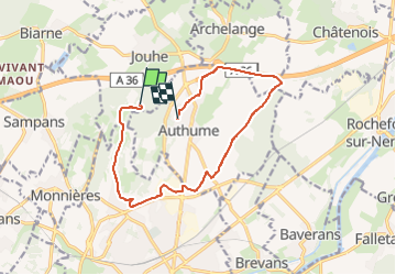

Lengte
12,3 km

Max. hoogte
341 m

Positief hoogteverschil
125 m
Km-Effort
14,2 km

Min. hoogte
225 m

Negatief hoogteverschil
202 m
Boucle
Neen
Datum van aanmaak :
2023-03-29 08:20:53.583
Laatste wijziging :
2023-03-29 09:14:01.473
48m
Moeilijkheid : Gemakkelijk

Gratisgps-wandelapplicatie
 SityTrail
IGN / Geografische instituten
SityTrail Plus
De wereld gaat voor u open
Over ons
Tocht Mountainbike van 12,3 km beschikbaar op Bourgondië-Franche-Comté, Jura, Jouhe. Deze tocht wordt voorgesteld door cmike39.
Plaatsbepaling
Land:
France
Regio :
Bourgondië-Franche-Comté
Departement/Provincie :
Jura
Gemeente :
Jouhe
Locatie:
Unknown
Vertrek:(Dec)
Vertrek:(UTM)
688598 ; 5222636 (31T) N.
Opmerkingen