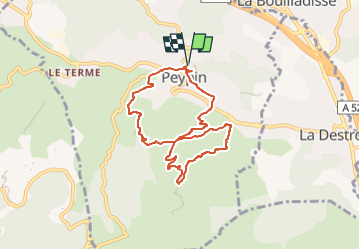
Peypin : La Cride-Mau Vallon

ARPF2
Gebruiker

Lengte
8,2 km

Max. hoogte
400 m

Positief hoogteverschil
361 m
Km-Effort
13 km

Min. hoogte
231 m

Negatief hoogteverschil
361 m
Boucle
Ja
Datum van aanmaak :
2023-03-31 08:07:36.045
Laatste wijziging :
2023-03-31 08:08:38.636
2h57
Moeilijkheid : Moeilijk

Gratisgps-wandelapplicatie
 SityTrail
IGN / Geografische instituten
SityTrail Plus
De wereld gaat voor u open
Over ons
Tocht Stappen van 8,2 km beschikbaar op Provence-Alpes-Côte d'Azur, Bouches-du-Rhône, Peypin. Deze tocht wordt voorgesteld door ARPF2.
Plaatsbepaling
Land:
France
Regio :
Provence-Alpes-Côte d'Azur
Departement/Provincie :
Bouches-du-Rhône
Gemeente :
Peypin
Locatie:
Unknown
Vertrek:(Dec)
Vertrek:(UTM)
708867 ; 4806825 (31T) N.
Opmerkingen