


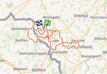
Heuvelland (RD1)+/-40Km

Ronalddef
Gebruiker

Lengte
39 km

Max. hoogte
156 m

Positief hoogteverschil
708 m
Km-Effort
48 km

Min. hoogte
34 m

Negatief hoogteverschil
707 m
Boucle
Ja
Datum van aanmaak :
2023-03-31 12:53:50.213
Laatste wijziging :
2023-03-31 12:58:38.5
--
Moeilijkheid : Moeilijk

Gratisgps-wandelapplicatie
 SityTrail
IGN / Geografische instituten
SityTrail Plus
De wereld gaat voor u open
Over ons
Tocht Trail van 39 km beschikbaar op Vlaanderen, West-Vlaanderen, Heuvelland. Deze tocht wordt voorgesteld door Ronalddef.
Beschrijving
Gemaakt met SityTrail /-40Km D 780m
Plaatsbepaling
Land:
Belgium
Regio :
Vlaanderen
Departement/Provincie :
West-Vlaanderen
Gemeente :
Heuvelland
Locatie:
Westouter
Vertrek:(Dec)
Vertrek:(UTM)
482082 ; 5627471 (31U) N.
Opmerkingen