


2014-11-17 Running Session

holtzv
Gebruiker GUIDE
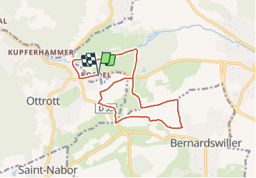

Lengte
9,4 km

Max. hoogte
259 m

Positief hoogteverschil
118 m
Km-Effort
11 km

Min. hoogte
221 m

Negatief hoogteverschil
119 m
Boucle
Ja
Datum van aanmaak :
2014-12-10 00:00:00.0
Laatste wijziging :
2014-12-10 00:00:00.0
--
Moeilijkheid : Medium

Gratisgps-wandelapplicatie
 SityTrail
IGN / Geografische instituten
SityTrail Plus
De wereld gaat voor u open
Over ons
Tocht Lopen van 9,4 km beschikbaar op Grand Est, Bas-Rhin, Obernai. Deze tocht wordt voorgesteld door holtzv.
Plaatsbepaling
Land:
France
Regio :
Grand Est
Departement/Provincie :
Bas-Rhin
Gemeente :
Obernai
Locatie:
Unknown
Vertrek:(Dec)
Vertrek:(UTM)
384426 ; 5368738 (32U) N.
Opmerkingen