


Trace G2 Lourdios Guy

mitch1952
Gebruiker
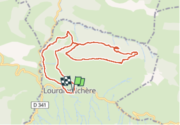

Lengte
11,8 km

Max. hoogte
983 m

Positief hoogteverschil
644 m
Km-Effort
20 km

Min. hoogte
388 m

Negatief hoogteverschil
647 m
Boucle
Ja
Datum van aanmaak :
2023-04-21 07:25:23.0
Laatste wijziging :
2023-04-21 13:36:37.999
6h08
Moeilijkheid : Onbekend

Gratisgps-wandelapplicatie
 SityTrail
IGN / Geografische instituten
SityTrail Plus
De wereld gaat voor u open
Over ons
Tocht Stappen van 11,8 km beschikbaar op Nieuw-Aquitanië, Pyrénées-Atlantiques, Lourdios-Ichère. Deze tocht wordt voorgesteld door mitch1952.
Plaatsbepaling
Land:
France
Regio :
Nieuw-Aquitanië
Departement/Provincie :
Pyrénées-Atlantiques
Gemeente :
Lourdios-Ichère
Locatie:
Unknown
Vertrek:(Dec)
Vertrek:(UTM)
690128 ; 4768894 (30T) N.
Opmerkingen