


Forêt de la Mairis

xelot
Gebruiker
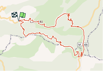

Lengte
13,1 km

Max. hoogte
1515 m

Positief hoogteverschil
855 m
Km-Effort
24 km

Min. hoogte
715 m

Negatief hoogteverschil
844 m
Boucle
Ja
Datum van aanmaak :
2014-12-10 00:00:00.0
Laatste wijziging :
2014-12-10 00:00:00.0
5h18
Moeilijkheid : Moeilijk

Gratisgps-wandelapplicatie
 SityTrail
IGN / Geografische instituten
SityTrail Plus
De wereld gaat voor u open
Over ons
Tocht Stappen van 13,1 km beschikbaar op Provence-Alpes-Côte d'Azur, Alpes-Maritimes, Lantosque. Deze tocht wordt voorgesteld door xelot.
Plaatsbepaling
Land:
France
Regio :
Provence-Alpes-Côte d'Azur
Departement/Provincie :
Alpes-Maritimes
Gemeente :
Lantosque
Locatie:
Unknown
Vertrek:(Dec)
Vertrek:(UTM)
365813 ; 4868200 (32T) N.
Opmerkingen