


SityTrail - Gueb-Munster

JCLUTT
Gebruiker

Lengte
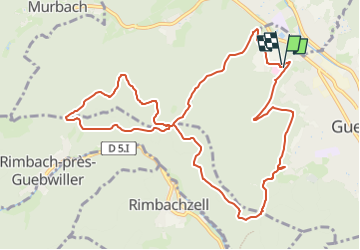
11,7 km

Max. hoogte
660 m

Positief hoogteverschil
437 m
Km-Effort
17,5 km

Min. hoogte
329 m

Negatief hoogteverschil
435 m
Boucle
Ja
Datum van aanmaak :
2023-05-09 15:23:22.561
Laatste wijziging :
2023-05-09 16:44:14.43
3h58
Moeilijkheid : Gemakkelijk

Gratisgps-wandelapplicatie
 SityTrail
IGN / Geografische instituten
SityTrail Plus
De wereld gaat voor u open
Over ons
Tocht Te voet van 11,7 km beschikbaar op Grand Est, Haut-Rhin, Guebwiller. Deze tocht wordt voorgesteld door JCLUTT.
Beschrijving
Belle balade de 12km à peu près sur les hauteurs de Soultz et Guebwiller.
Plaatsbepaling
Land:
France
Regio :
Grand Est
Departement/Provincie :
Haut-Rhin
Gemeente :
Guebwiller
Locatie:
Unknown
Vertrek:(Dec)
Vertrek:(UTM)
365211 ; 5308558 (32T) N.
Opmerkingen