


Tinou/gege la suisse normande

zot
Gebruiker

Lengte
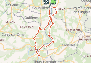
16,6 km

Max. hoogte
135 m

Positief hoogteverschil
426 m
Km-Effort
22 km

Min. hoogte
18 m

Negatief hoogteverschil
421 m
Boucle
Ja
Datum van aanmaak :
2023-05-14 09:50:33.0
Laatste wijziging :
2023-05-14 15:56:31.397
3h53
Moeilijkheid : Medium

Gratisgps-wandelapplicatie
 SityTrail
IGN / Geografische instituten
SityTrail Plus
De wereld gaat voor u open
Over ons
Tocht Stappen van 16,6 km beschikbaar op Normandië, Calvados, Montillières-sur-Orne. Deze tocht wordt voorgesteld door zot.
Plaatsbepaling
Land:
France
Regio :
Normandië
Departement/Provincie :
Calvados
Gemeente :
Montillières-sur-Orne
Locatie:
Goupillières
Vertrek:(Dec)
Vertrek:(UTM)
685098 ; 5434209 (30U) N.
Opmerkingen