


col de jou ,PY ,CABALL MORT

FAUCET
Gebruiker
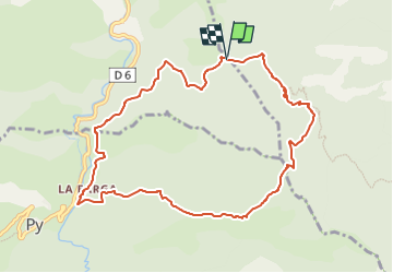

Lengte
10,5 km

Max. hoogte
1750 m

Positief hoogteverschil
844 m
Km-Effort
22 km

Min. hoogte
934 m

Negatief hoogteverschil
836 m
Boucle
Ja
Datum van aanmaak :
2023-05-17 13:21:44.206
Laatste wijziging :
2023-05-17 13:21:46.363
4h56
Moeilijkheid : Zeer moeilijk

Gratisgps-wandelapplicatie
 SityTrail
IGN / Geografische instituten
SityTrail Plus
De wereld gaat voor u open
Over ons
Tocht Stappen van 10,5 km beschikbaar op Occitanië, Pyrénées-Orientales, Sahorre. Deze tocht wordt voorgesteld door FAUCET.
Plaatsbepaling
Land:
France
Regio :
Occitanië
Departement/Provincie :
Pyrénées-Orientales
Gemeente :
Sahorre
Locatie:
Unknown
Vertrek:(Dec)
Vertrek:(UTM)
449165 ; 4707148 (31T) N.
Opmerkingen