


Messon_30

DomifaC
Gebruiker
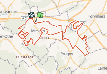

Lengte
31 km

Max. hoogte
253 m

Positief hoogteverschil
723 m
Km-Effort
41 km

Min. hoogte
149 m

Negatief hoogteverschil
724 m
Boucle
Ja
Datum van aanmaak :
2023-05-27 05:13:51.727
Laatste wijziging :
2023-05-27 15:10:06.01
7h03
Moeilijkheid : Moeilijk

Gratisgps-wandelapplicatie
 SityTrail
IGN / Geografische instituten
SityTrail Plus
De wereld gaat voor u open
Over ons
Tocht Noords wandelen van 31 km beschikbaar op Grand Est, Aube, Messon. Deze tocht wordt voorgesteld door DomifaC.
Plaatsbepaling
Land:
France
Regio :
Grand Est
Departement/Provincie :
Aube
Gemeente :
Messon
Locatie:
Unknown
Vertrek:(Dec)
Vertrek:(UTM)
567224 ; 5346753 (31U) N.
Opmerkingen