


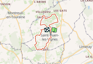
Saint Ouen les Vignes

Pascal Bernaud
Gebruiker

Lengte
13,1 km

Max. hoogte
113 m

Positief hoogteverschil
162 m
Km-Effort
15,3 km

Min. hoogte
67 m

Negatief hoogteverschil
160 m
Boucle
Ja
Datum van aanmaak :
2023-06-08 07:14:25.0
Laatste wijziging :
2023-06-08 10:34:36.597
2h40
Moeilijkheid : Moeilijk

Gratisgps-wandelapplicatie
 SityTrail
IGN / Geografische instituten
SityTrail Plus
De wereld gaat voor u open
Over ons
Tocht Stappen van 13,1 km beschikbaar op Centre-Val de Loire, Indre-et-Loire, Saint-Ouen-les-Vignes. Deze tocht wordt voorgesteld door Pascal Bernaud.
Plaatsbepaling
Land:
France
Regio :
Centre-Val de Loire
Departement/Provincie :
Indre-et-Loire
Gemeente :
Saint-Ouen-les-Vignes
Locatie:
Unknown
Vertrek:(Dec)
Vertrek:(UTM)
348809 ; 5259225 (31T) N.
Opmerkingen