


enduro hohrod

veroarvinberod
Gebruiker
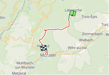

Lengte
13,3 km

Max. hoogte
1046 m

Positief hoogteverschil
304 m
Km-Effort
19,1 km

Min. hoogte
381 m

Negatief hoogteverschil
843 m
Boucle
Neen
Datum van aanmaak :
2023-06-17 11:32:16.072
Laatste wijziging :
2023-06-17 14:25:51.872
2h53
Moeilijkheid : Gemakkelijk

Gratisgps-wandelapplicatie
 SityTrail
IGN / Geografische instituten
SityTrail Plus
De wereld gaat voor u open
Over ons
Tocht Mountainbike van 13,3 km beschikbaar op Grand Est, Haut-Rhin, Labaroche. Deze tocht wordt voorgesteld door veroarvinberod.
Plaatsbepaling
Land:
France
Regio :
Grand Est
Departement/Provincie :
Haut-Rhin
Gemeente :
Labaroche
Locatie:
Unknown
Vertrek:(Dec)
Vertrek:(UTM)
364773 ; 5328375 (32U) N.
Opmerkingen