


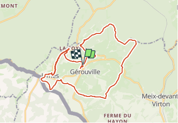
Gerouville

BrigitteBertrand
Gebruiker

Lengte
22 km

Max. hoogte
345 m

Positief hoogteverschil
339 m
Km-Effort
27 km

Min. hoogte
221 m

Negatief hoogteverschil
337 m
Boucle
Ja
Datum van aanmaak :
2023-06-25 07:25:52.0
Laatste wijziging :
2023-06-25 13:30:25.076
6h03
Moeilijkheid : Zeer moeilijk

Gratisgps-wandelapplicatie
 SityTrail
IGN / Geografische instituten
SityTrail Plus
De wereld gaat voor u open
Over ons
Tocht Stappen van 22 km beschikbaar op Wallonië, Luxemburg, Meix-devant-Virton. Deze tocht wordt voorgesteld door BrigitteBertrand.
Beschrijving
Ir - 239 - Autours de Gerouville
Foto's


27 fotos in totaal. Klik op een foto om ze allemaal in de galerij weer te geven.
Plaatsbepaling
Land:
Belgium
Regio :
Wallonië
Departement/Provincie :
Luxemburg
Gemeente :
Meix-devant-Virton
Locatie:
Unknown
Vertrek:(Dec)
Vertrek:(UTM)
675339 ; 5499387 (31U) N.
Opmerkingen