


Le chemin de l'enfer

Alain28/01
Gebruiker
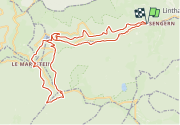

Lengte
24 km

Max. hoogte
1189 m

Positief hoogteverschil
1015 m
Km-Effort
37 km

Min. hoogte
502 m

Negatief hoogteverschil
1013 m
Boucle
Ja
Datum van aanmaak :
2023-07-08 09:44:09.274
Laatste wijziging :
2023-07-08 09:45:28.497
8h27
Moeilijkheid : Moeilijk

Gratisgps-wandelapplicatie
 SityTrail
IGN / Geografische instituten
SityTrail Plus
De wereld gaat voor u open
Over ons
Tocht Te voet van 24 km beschikbaar op Grand Est, Haut-Rhin, Linthal. Deze tocht wordt voorgesteld door Alain28/01.
Plaatsbepaling
Land:
France
Regio :
Grand Est
Departement/Provincie :
Haut-Rhin
Gemeente :
Linthal
Locatie:
Unknown
Vertrek:(Dec)
Vertrek:(UTM)
358993 ; 5311546 (32T) N.
Opmerkingen