


carrosetapa4

ARVIEU
Gebruiker
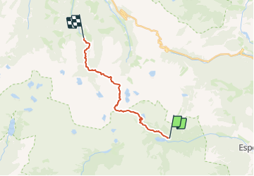

Lengte
16 km

Max. hoogte
2600 m

Positief hoogteverschil
930 m
Km-Effort
29 km

Min. hoogte
1761 m

Negatief hoogteverschil
1122 m
Boucle
Neen
Datum van aanmaak :
2023-07-27 16:27:09.514
Laatste wijziging :
2023-07-27 16:28:02.602
6h35
Moeilijkheid : Moeilijk

Gratisgps-wandelapplicatie
 SityTrail
IGN / Geografische instituten
SityTrail Plus
De wereld gaat voor u open
Over ons
Tocht Stappen van 16 km beschikbaar op Catalonië, Lerida, Espot. Deze tocht wordt voorgesteld door ARVIEU.
Plaatsbepaling
Land:
Spain
Regio :
Catalonië
Departement/Provincie :
Lerida
Gemeente :
Espot
Locatie:
Unknown
Vertrek:(Dec)
Vertrek:(UTM)
336789 ; 4716442 (31T) N.
Opmerkingen