


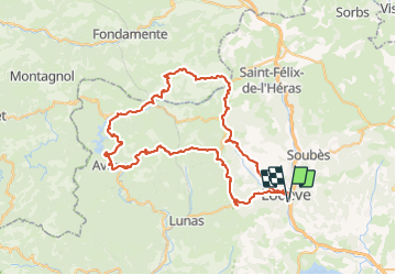
Lodève Le Perthus le Clapier Avène Fontbine Les Bonzes Lodève

ARVIEU
Gebruiker

Lengte
80 km

Max. hoogte
863 m

Positief hoogteverschil
1820 m
Km-Effort
105 km

Min. hoogte
155 m

Negatief hoogteverschil
1826 m
Boucle
Ja
Datum van aanmaak :
2023-07-27 18:27:27.207
Laatste wijziging :
2023-07-27 18:33:21.1
4h30
Moeilijkheid : Moeilijk

Gratisgps-wandelapplicatie
 SityTrail
IGN / Geografische instituten
SityTrail Plus
De wereld gaat voor u open
Over ons
Tocht Fiets van 80 km beschikbaar op Occitanië, Hérault, Lodève. Deze tocht wordt voorgesteld door ARVIEU.
Plaatsbepaling
Land:
France
Regio :
Occitanië
Departement/Provincie :
Hérault
Gemeente :
Lodève
Locatie:
Unknown
Vertrek:(Dec)
Vertrek:(UTM)
526032 ; 4841232 (31T) N.
Opmerkingen