


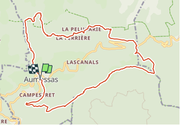
Aumessas, col Mouzoules

34christophe
Gebruiker

Lengte
13,2 km

Max. hoogte
928 m

Positief hoogteverschil
769 m
Km-Effort
23 km

Min. hoogte
431 m

Negatief hoogteverschil
768 m
Boucle
Ja
Datum van aanmaak :
2023-08-10 17:12:03.529
Laatste wijziging :
2023-08-10 17:14:56.673
5h20
Moeilijkheid : Medium

Gratisgps-wandelapplicatie
 SityTrail
IGN / Geografische instituten
SityTrail Plus
De wereld gaat voor u open
Over ons
Tocht Te voet van 13,2 km beschikbaar op Occitanië, Gard, Aumessas. Deze tocht wordt voorgesteld door 34christophe.
Beschrijving
Aumessas, Vernèdes, Travers, Mouzoules, Rocher du Comte, Aumessas
Plaatsbepaling
Land:
France
Regio :
Occitanië
Departement/Provincie :
Gard
Gemeente :
Aumessas
Locatie:
Unknown
Vertrek:(Dec)
Vertrek:(UTM)
540367 ; 4871010 (31T) N.
Opmerkingen