


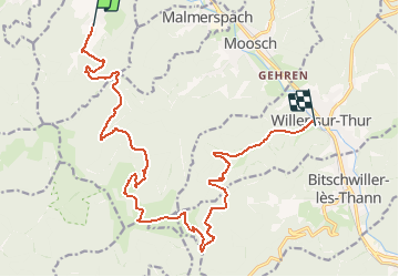
Circuit Sundgau - Mitzach - Willer sur Thur

Tourisme Equestre Alsace
Promouvoir le Tourisme Equestre en Alsace GUIDE+

Lengte
18,3 km

Max. hoogte
1162 m

Positief hoogteverschil
843 m
Km-Effort
30 km

Min. hoogte
366 m

Negatief hoogteverschil
953 m
Boucle
Neen
Datum van aanmaak :
2015-01-15 00:00:00.0
Laatste wijziging :
2019-01-07 11:41:54.815
3h31
Moeilijkheid : Medium

Gratisgps-wandelapplicatie
 SityTrail
IGN / Geografische instituten
SityTrail Plus
De wereld gaat voor u open
Over ons
Tocht Paardrijden van 18,3 km beschikbaar op Grand Est, Haut-Rhin, Mitzach. Deze tocht wordt voorgesteld door Tourisme Equestre Alsace.
Foto's


Plaatsbepaling
Land:
France
Regio :
Grand Est
Departement/Provincie :
Haut-Rhin
Gemeente :
Mitzach
Locatie:
Unknown
Vertrek:(Dec)
Vertrek:(UTM)
350419 ; 5303063 (32T) N.
Opmerkingen