Tocht Elektrische fiets Saint-Jacques-des-Blats - gliziou - Photo
 ra2000
ra2000

Gebruiker

© OpenStreetMap contributors
Lengte
Lengte
19,2 km
Max. hoogte
Max. hoogte
1375 m
Positief hoogteverschil
486 m
Km-Effort
Km-Effort  
28 km
Min. hoogte
Min. hoogte
777 m
Negatief hoogteverschil
1048 m
Boucle
Boucle
Neen
Datum van aanmaak :
2023-08-14 14:49:15.106
Laatste wijziging :
2023-08-16 13:09:47.851

(0 Bericht)

Elektrische fiets
Elektrische fiets
52m
Moeilijkheid : Zeer moeilijk

Scan deze QR-code om de tocht te openen in de SityTrail-applicatie

Gratisgps-wandelapplicatie

Logo SityTrail SityTrail

IGN / Geografische instituten

SityTrail uit de App Store downloaden SityTrail uit Google Play downloaden

Logo SityTrail SityTrail World

De wereld gaat voor u open

SityTrail uit de App Store downloaden SityTrail uit Google Play downloaden SityTrail op Huawei AppGallery downloaden

Over ons

Tocht Elektrische fiets van 19,2 km beschikbaar op Auvergne-Rhône-Alpes, Cantal, Saint-Jacques-des-Blats. Deze tocht wordt voorgesteld door ra2000.

Hoogteprofiel

Plaatsbepaling

Land:
France
Regio :
Auvergne-Rhône-Alpes
Departement/Provincie :
Cantal
Gemeente :
Saint-Jacques-des-Blats
Locatie:
Unknown
Vertrek:(UTM)
476754 ; 4991238 (31T) N.

Wandeltochten in de omgeving

Tocht Stappen Laveissière - Le Puy Griou de Super Lioran - Photo
Stappen
tracegps

Stappen

Medium
(2)
Laveissière, Auvergne-Rhône-Alpes, Cantal, France
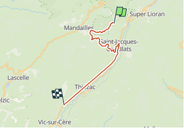
11,9 km | 19,7 km-effort
5h 0min
Ja
Tocht Stappen Laveissière - Le plomb du Cantal - Le Lioran - Photo
Stappen
tracegps

Stappen

Medium
(1)
Laveissière, Auvergne-Rhône-Alpes, Cantal, France
14,4 km | 27 km-effort
6h 0min
Ja
Tocht Stappen Laveissière - Les crêtes du Cantal - Le Lioran - Photo
Stappen
tracegps

Stappen

Moeilijk
(4)
Laveissière, Auvergne-Rhône-Alpes, Cantal, France
28 km | 51 km-effort
7h 30min
Ja
Tocht Stappen Mandailles-Saint-Julien - L'Elancèze - Photo
Stappen
tracegps

Stappen

Moeilijk
(1)
Mandailles-Saint-Julien, Auvergne-Rhône-Alpes, Cantal, France
12,8 km | 24 km-effort
5h 0min
Ja
Tocht Stappen Laveissière - le Peyre Arse - Le Lioran - Photo
Stappen
tracegps

Stappen

Moeilijk
(1)
Laveissière, Auvergne-Rhône-Alpes, Cantal, France
11,2 km | 19,4 km-effort
4h 0min
Neen
Tocht Stappen Laveissière - Lioran 2023-08-18 Col de Rombière Col du Pertus A/R - Photo
Stappen
marionneau

Stappen

Gemakkelijk
(1)
Laveissière, Auvergne-Rhône-Alpes, Cantal, France
12,5 km | 18,8 km-effort
4h 14min
Ja
Tocht Stappen Laveissière - Lioran 2023-08-11 Col du Pertus - Photo
Stappen
marionneau

Stappen

Medium
(1)
Laveissière, Auvergne-Rhône-Alpes, Cantal, France
17,3 km | 25 km-effort
2h 57min
Ja
Tocht Stappen Laveissière - Lioran 2023-08-09 Puy de Seycheuse - Photo
Stappen
marionneau

Stappen

Zeer moeilijk
(1)
Laveissière, Auvergne-Rhône-Alpes, Cantal, France
13,9 km | 23 km-effort
5h 20min
Ja
Tocht Stappen Laveissière - SityTrail - TABAZE Plomb du Cantal - Photo
Stappen
PsyPezman

Stappen

Zeer moeilijk
Laveissière, Auvergne-Rhône-Alpes, Cantal, France
35 km | 61 km-effort
13h 53min
Ja


Sluiten
Mijn abonnementen