


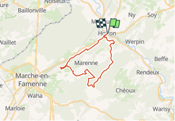
Cirkwi-MENIL_-_VTT_(Commune_HOTTON)

so.duchateau
Gebruiker

Lengte
22 km

Max. hoogte
411 m

Positief hoogteverschil
476 m
Km-Effort
28 km

Min. hoogte
176 m

Negatief hoogteverschil
476 m
Boucle
Ja
Datum van aanmaak :
2023-09-01 12:02:56.559
Laatste wijziging :
2023-09-01 12:14:13.369
0m
Moeilijkheid : Heel gemakkelijk

Gratisgps-wandelapplicatie
 SityTrail
IGN / Geografische instituten
SityTrail Plus
De wereld gaat voor u open
Over ons
Tocht Fiets van 22 km beschikbaar op Wallonië, Luxemburg, Hotton. Deze tocht wordt voorgesteld door so.duchateau.
Beschrijving
Balisage: Vert et N° 4 Dénivelé 461m Ce circuit fait parti de la carte de VTT de Hotton-Durbuy. Vous pouvez la commander via http://marando.be/catalog/index/view/id/198/lang/fr
Plaatsbepaling
Land:
Belgium
Regio :
Wallonië
Departement/Provincie :
Luxemburg
Gemeente :
Hotton
Locatie:
Unknown
Vertrek:(Dec)
Vertrek:(UTM)
674461 ; 5571316 (31U) N.
Opmerkingen