


Circuit N° 2 de Mandeure (modif 2023)

tiene
Gebruiker
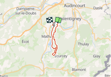

Lengte
15,9 km

Max. hoogte
594 m

Positief hoogteverschil
343 m
Km-Effort
21 km

Min. hoogte
328 m

Negatief hoogteverschil
343 m
Boucle
Ja
Datum van aanmaak :
2023-09-01 12:41:08.38
Laatste wijziging :
2023-09-06 12:56:53.226
1h07
Moeilijkheid : Moeilijk

Gratisgps-wandelapplicatie
 SityTrail
IGN / Geografische instituten
SityTrail Plus
De wereld gaat voor u open
Over ons
Tocht Stappen van 15,9 km beschikbaar op Bourgondië-Franche-Comté, Doubs, Mandeure. Deze tocht wordt voorgesteld door tiene.
Plaatsbepaling
Land:
France
Regio :
Bourgondië-Franche-Comté
Departement/Provincie :
Doubs
Gemeente :
Mandeure
Locatie:
Unknown
Vertrek:(Dec)
Vertrek:(UTM)
333841 ; 5257495 (32T) N.
Opmerkingen