


forêt de chaux

phileasy
Gebruiker
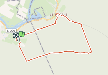

Lengte
9,1 km

Max. hoogte
253 m

Positief hoogteverschil
122 m
Km-Effort
10,7 km

Min. hoogte
205 m

Negatief hoogteverschil
122 m
Boucle
Ja
Datum van aanmaak :
2023-09-20 07:04:27.441
Laatste wijziging :
2023-09-20 09:48:28.838
2h43
Moeilijkheid : Gemakkelijk

Gratisgps-wandelapplicatie
 SityTrail
IGN / Geografische instituten
SityTrail Plus
De wereld gaat voor u open
Over ons
Tocht Stappen van 9,1 km beschikbaar op Bourgondië-Franche-Comté, Jura, Dole. Deze tocht wordt voorgesteld door phileasy.
Plaatsbepaling
Land:
France
Regio :
Bourgondië-Franche-Comté
Departement/Provincie :
Jura
Gemeente :
Dole
Locatie:
Unknown
Vertrek:(Dec)
Vertrek:(UTM)
691509 ; 5216588 (31T) N.
Opmerkingen