


TL 09/23, Parking Neurod - Croix de l'Abbé Meyer - Rainkopf - Firstmiss et retour

patrickbeyrath
Gebruiker
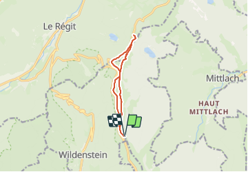

Lengte
8,8 km

Max. hoogte
1304 m

Positief hoogteverschil
326 m
Km-Effort
13,1 km

Min. hoogte
1183 m

Negatief hoogteverschil
327 m
Boucle
Ja
Datum van aanmaak :
2023-09-27 07:31:35.966
Laatste wijziging :
2023-09-30 07:28:31.058
2h58
Moeilijkheid : Gemakkelijk

Gratisgps-wandelapplicatie
 SityTrail
IGN / Geografische instituten
SityTrail Plus
De wereld gaat voor u open
Over ons
Tocht Te voet van 8,8 km beschikbaar op Grand Est, Haut-Rhin, Metzeral. Deze tocht wordt voorgesteld door patrickbeyrath.
Plaatsbepaling
Land:
France
Regio :
Grand Est
Departement/Provincie :
Haut-Rhin
Gemeente :
Metzeral
Locatie:
Unknown
Vertrek:(Dec)
Vertrek:(UTM)
349448 ; 5316515 (32T) N.
Opmerkingen