


ariane_boucle_macaron-13064170-1696408171-276

topolino
Gebruiker
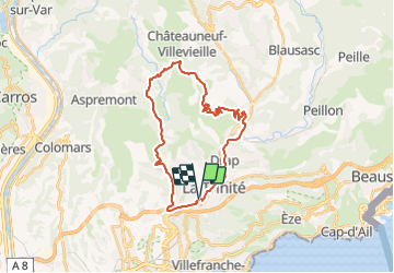

Lengte
30 km

Max. hoogte
733 m

Positief hoogteverschil
879 m
Km-Effort
41 km

Min. hoogte
42 m

Negatief hoogteverschil
880 m
Boucle
Ja
Datum van aanmaak :
2023-10-04 08:30:09.448
Laatste wijziging :
2023-10-04 08:30:09.448
2h52
Moeilijkheid : Zeer moeilijk

Gratisgps-wandelapplicatie
 SityTrail
IGN / Geografische instituten
SityTrail Plus
De wereld gaat voor u open
Over ons
Tocht Mountainbike van 30 km beschikbaar op Provence-Alpes-Côte d'Azur, Alpes-Maritimes, Nice. Deze tocht wordt voorgesteld door topolino.
Plaatsbepaling
Land:
France
Regio :
Provence-Alpes-Côte d'Azur
Departement/Provincie :
Alpes-Maritimes
Gemeente :
Nice
Locatie:
Unknown
Vertrek:(Dec)
Vertrek:(UTM)
363454 ; 4844175 (32T) N.
Opmerkingen