Tocht Stappen Sémalens - Sentier des amoureux Semalens - Photo

Sentier des amoureux Semalens

 tabouelle
tabouelle

Gebruiker

© OpenStreetMap contributors
Lengte
Lengte
8,7 km
Max. hoogte
Max. hoogte
163 m
Positief hoogteverschil
48 m
Km-Effort
Km-Effort  
9,3 km
Min. hoogte
Min. hoogte
152 m
Negatief hoogteverschil
46 m
Boucle
Boucle
Ja
Datum van aanmaak :
2023-10-06 07:38:10.646
Laatste wijziging :
2023-10-06 10:11:13.022

(0 Bericht)

Stappen
Stappen
2h20
Moeilijkheid : Heel gemakkelijk

Scan deze QR-code om de tocht te openen in de SityTrail-applicatie

Gratisgps-wandelapplicatie

Logo SityTrail SityTrail

IGN / Geografische instituten

SityTrail uit de App Store downloaden SityTrail uit Google Play downloaden

Logo SityTrail SityTrail World

De wereld gaat voor u open

SityTrail uit de App Store downloaden SityTrail uit Google Play downloaden SityTrail op Huawei AppGallery downloaden

Over ons

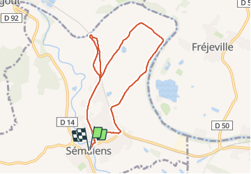
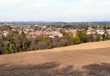
Tocht Stappen van 8,7 km beschikbaar op Occitanië, Tarn, Sémalens. Deze tocht wordt voorgesteld door tabouelle.

Beschrijving

très facile mais beaucoup trop de goudron.
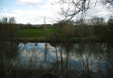
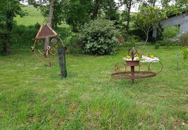
halte au pont Antoinette sympathique

Hoogteprofiel

Plaatsbepaling

Land:
France
Regio :
Occitanië
Departement/Provincie :
Tarn
Gemeente :
Sémalens
Locatie:
Unknown
Vertrek:(UTM)
428271 ; 4826946 (31T) N.

Wandeltochten in de omgeving

Tocht Stappen Puylaurens - Boucle de Saint Sébastien - Puylaurens - Photo
Stappen
tracegps

Stappen

Medium
Puylaurens, Occitanië, Tarn, France
12 km | 16,3 km-effort
3h 30min
Ja
Tocht Lopen Vielmur-sur-Agout - Les Eoliennes de Cuq Serviès - Vielmur sur Agout - Photo
Lopen
tracegps

Lopen

Moeilijk
Vielmur-sur-Agout, Occitanië, Tarn, France
18,9 km | 22 km-effort
1h 40min
Ja
Tocht Mountainbike Vielmur-sur-Agout - Les Eoliennes de Cuq Serviès - Vielmur sur Agout - Photo
Mountainbike
tracegps

Mountainbike

Medium
Vielmur-sur-Agout, Occitanië, Tarn, France
18,9 km | 22 km-effort
1h 15min
Ja
Tocht Stappen Soual - soual - Photo
Stappen
cappelle

Stappen

Gemakkelijk
Soual, Occitanië, Tarn, France
11,7 km | 13,3 km-effort
2h 46min
Ja
Tocht Andere activiteiten Puylaurens - Saint-Sébastien - Photo
Andere activiteiten
jpp2caunes

Andere activiteiten

Heel gemakkelijk
Puylaurens, Occitanië, Tarn, France
12,8 km | 17,2 km-effort
6h 27min
Ja
Tocht Stappen Puylaurens - Puylaurens St sebastien  - Photo
Stappen
arqdan

Stappen

Heel gemakkelijk
Puylaurens, Occitanië, Tarn, France
12,8 km | 17,2 km-effort
3h 38min
Ja
Tocht Stappen Soual - LES PIGEONNIERS - Photo
Stappen
CANON2

Stappen

Heel gemakkelijk
Soual, Occitanië, Tarn, France
11,7 km | 13,3 km-effort
2h 55min
Ja
Tocht Stappen Puylaurens - 81_Vielmur - Photo
Stappen
jab31

Stappen

Gemakkelijk
Puylaurens, Occitanië, Tarn, France
12,6 km | 17 km-effort
2h 28min
Ja
Tocht Mountainbike Saïx - Base de loisirs du DICOSA - Semalens - Photo
Mountainbike
tracegps

Mountainbike

Gemakkelijk
Saïx, Occitanië, Tarn, France
3,3 km | 3,5 km-effort
30min
Ja


Sluiten
Mijn abonnementen