


2023-10-17_18h09m39_F12 1

LUTZMarc
Gebruiker

Lengte
17,1 km

Max. hoogte
471 m

Positief hoogteverschil
457 m
Km-Effort
23 km

Min. hoogte
245 m

Negatief hoogteverschil
456 m
Boucle
Ja
Datum van aanmaak :
2023-10-17 16:09:39.302
Laatste wijziging :
2024-11-01 09:08:09.708
5h16
Moeilijkheid : Moeilijk

Gratisgps-wandelapplicatie
 SityTrail
IGN / Geografische instituten
SityTrail Plus
De wereld gaat voor u open
Over ons
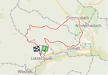
Tocht Stappen van 17,1 km beschikbaar op Grand Est, Bas-Rhin, Lutzelhouse. Deze tocht wordt voorgesteld door LUTZMarc.
Beschrijving
Départ raide.
Resto Le saint Florent à Oberhaslach.
Plaatsbepaling
Land:
France
Regio :
Grand Est
Departement/Provincie :
Bas-Rhin
Gemeente :
Lutzelhouse
Locatie:
Unknown
Vertrek:(Dec)
Vertrek:(UTM)
373531 ; 5375713 (32U) N.
Opmerkingen