


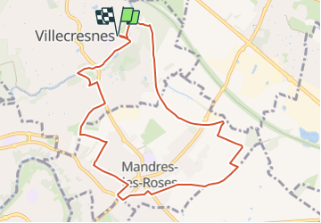
Villecresnes Mandres 8_10 du 22_11_2023 Version courte

LIMOS
Gebruiker

Lengte
9,7 km

Max. hoogte
97 m

Positief hoogteverschil
66 m
Km-Effort
10,6 km

Min. hoogte
53 m

Negatief hoogteverschil
66 m
Boucle
Ja
Datum van aanmaak :
2023-10-27 09:45:54.254
Laatste wijziging :
2023-10-27 09:48:10.871
2h24
Moeilijkheid : Gemakkelijk

Gratisgps-wandelapplicatie
 SityTrail
IGN / Geografische instituten
SityTrail Plus
De wereld gaat voor u open
Over ons
Tocht Te voet van 9,7 km beschikbaar op Île-de-France, Val-de-Marne, Villecresnes. Deze tocht wordt voorgesteld door LIMOS.
Plaatsbepaling
Land:
France
Regio :
Île-de-France
Departement/Provincie :
Val-de-Marne
Gemeente :
Villecresnes
Locatie:
Unknown
Vertrek:(Dec)
Vertrek:(UTM)
466245 ; 5396539 (31U) N.
Opmerkingen