


2023-10-31_20h22m34_C25

LUTZMarc
Gebruiker

Lengte
16,3 km

Max. hoogte
478 m

Positief hoogteverschil
387 m
Km-Effort
21 km

Min. hoogte
199 m

Negatief hoogteverschil
386 m
Boucle
Ja
Datum van aanmaak :
2023-10-31 19:22:35.072
Laatste wijziging :
2023-12-04 17:49:17.829
4h52
Moeilijkheid : Zeer moeilijk

Gratisgps-wandelapplicatie
 SityTrail
IGN / Geografische instituten
SityTrail Plus
De wereld gaat voor u open
Over ons
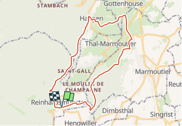
Tocht Stappen van 16,3 km beschikbaar op Grand Est, Bas-Rhin, Reinhardsmunster. Deze tocht wordt voorgesteld door LUTZMarc.
Beschrijving
Magnifique paysage avec de beau point de vue.
Resto Au bain à Haegen..
Pas difficile.
Plaatsbepaling
Land:
France
Regio :
Grand Est
Departement/Provincie :
Bas-Rhin
Gemeente :
Reinhardsmunster
Locatie:
Unknown
Vertrek:(Dec)
Vertrek:(UTM)
376338 ; 5392595 (32U) N.
Opmerkingen