


2023-11-03_14h12m05_B28 La Sauvie - Vallée de la Vis

34christophe
Gebruiker
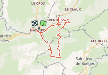

Lengte
16,9 km

Max. hoogte
694 m

Positief hoogteverschil
618 m
Km-Effort
25 km

Min. hoogte
220 m

Negatief hoogteverschil
618 m
Boucle
Ja
Datum van aanmaak :
2023-11-03 13:12:06.537
Laatste wijziging :
2024-04-01 16:49:48.489
5h43
Moeilijkheid : Moeilijk

Gratisgps-wandelapplicatie
 SityTrail
IGN / Geografische instituten
SityTrail Plus
De wereld gaat voor u open
Over ons
Tocht Stappen van 16,9 km beschikbaar op Occitanië, Gard, Rogues. Deze tocht wordt voorgesteld door 34christophe.
Beschrijving
variante en 17km
Plaatsbepaling
Land:
France
Regio :
Occitanië
Departement/Provincie :
Gard
Gemeente :
Rogues
Locatie:
Unknown
Vertrek:(Dec)
Vertrek:(UTM)
545419 ; 4855862 (31T) N.
Opmerkingen
Madieres magnifique village 1 er moitié de retour, etroite et passage très étroit en bord de falaise. Soyez prudents.