


2015 02 16 FR Staufen Hohburg Eguisheim

staubalex
Gebruiker
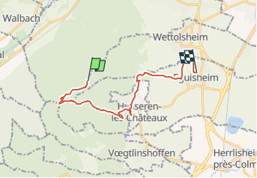

Lengte
10,4 km

Max. hoogte
753 m

Positief hoogteverschil
165 m
Km-Effort
14,1 km

Min. hoogte
196 m

Negatief hoogteverschil
620 m
Boucle
Neen
Datum van aanmaak :
2015-02-16 00:00:00.0
Laatste wijziging :
2015-02-16 00:00:00.0
50m
Moeilijkheid : Medium

Gratisgps-wandelapplicatie
 SityTrail
IGN / Geografische instituten
SityTrail Plus
De wereld gaat voor u open
Over ons
Tocht Andere activiteiten van 10,4 km beschikbaar op Grand Est, Haut-Rhin, Wettolsheim. Deze tocht wordt voorgesteld door staubalex.
Plaatsbepaling
Land:
France
Regio :
Grand Est
Departement/Provincie :
Haut-Rhin
Gemeente :
Wettolsheim
Locatie:
Unknown
Vertrek:(Dec)
Vertrek:(UTM)
370024 ; 5322640 (32U) N.
Opmerkingen