


Pechbusque 10 fait 2023

pidjam
Gebruiker
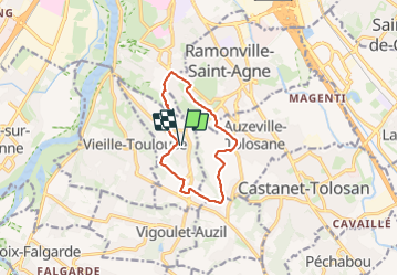

Lengte
10,4 km

Max. hoogte
278 m

Positief hoogteverschil
215 m
Km-Effort
13,3 km

Min. hoogte
181 m

Negatief hoogteverschil
216 m
Boucle
Ja
Datum van aanmaak :
2023-11-26 13:08:52.553
Laatste wijziging :
2023-11-26 15:49:03.351
2h23
Moeilijkheid : Medium

Gratisgps-wandelapplicatie
 SityTrail
IGN / Geografische instituten
SityTrail Plus
De wereld gaat voor u open
Over ons
Tocht Stappen van 10,4 km beschikbaar op Occitanië, Haute-Garonne, Pechbusque. Deze tocht wordt voorgesteld door pidjam.
Plaatsbepaling
Land:
France
Regio :
Occitanië
Departement/Provincie :
Haute-Garonne
Gemeente :
Pechbusque
Locatie:
Unknown
Vertrek:(Dec)
Vertrek:(UTM)
375550 ; 4820491 (31T) N.
Opmerkingen