


ST_bg_delete

My Switzerland
Optez pour le retour à la nature GUIDE+
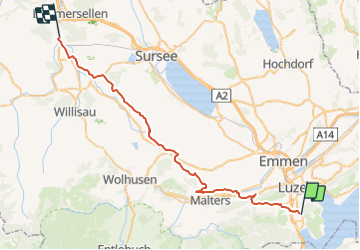

Lengte
42 km

Max. hoogte
736 m

Positief hoogteverschil
698 m
Km-Effort
51 km

Min. hoogte
446 m

Negatief hoogteverschil
660 m
Boucle
Neen
Datum van aanmaak :
2014-12-10 00:00:00.0
Laatste wijziging :
2014-12-10 00:00:00.0
2h02
Moeilijkheid : Onbekend

Gratisgps-wandelapplicatie
 SityTrail
IGN / Geografische instituten
SityTrail Plus
De wereld gaat voor u open
Over ons
Tocht Fiets van 42 km beschikbaar op Luzern, Onbekend, Horw. Deze tocht wordt voorgesteld door My Switzerland.
Plaatsbepaling
Land:
Switzerland
Regio :
Luzern
Departement/Provincie :
Onbekend
Gemeente :
Horw
Locatie:
Unknown
Vertrek:(Dec)
Vertrek:(UTM)
447388 ; 5208179 (32T) N.
Opmerkingen