


2023.11.30 - Cabrières, Poulx

rando30129
Gebruiker
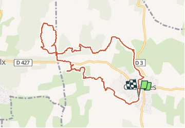

Lengte
13,3 km

Max. hoogte
209 m

Positief hoogteverschil
234 m
Km-Effort
16,4 km

Min. hoogte
108 m

Negatief hoogteverschil
234 m
Boucle
Ja
Datum van aanmaak :
2023-11-30 12:18:18.0
Laatste wijziging :
2023-11-30 17:21:09.019
3h44
Moeilijkheid : Moeilijk

Gratisgps-wandelapplicatie
 SityTrail
IGN / Geografische instituten
SityTrail Plus
De wereld gaat voor u open
Over ons
Tocht Stappen van 13,3 km beschikbaar op Occitanië, Gard, Cabrières. Deze tocht wordt voorgesteld door rando30129.
Plaatsbepaling
Land:
France
Regio :
Occitanië
Departement/Provincie :
Gard
Gemeente :
Cabrières
Locatie:
Unknown
Vertrek:(Dec)
Vertrek:(UTM)
618198 ; 4862037 (31T) N.
Opmerkingen