


Asse

Geert H.
Gebruiker
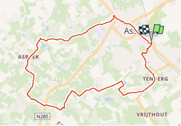

Lengte
10,6 km

Max. hoogte
85 m

Positief hoogteverschil
168 m
Km-Effort
12,8 km

Min. hoogte
25 m

Negatief hoogteverschil
167 m
Boucle
Ja
Datum van aanmaak :
2023-12-01 14:43:22.084
Laatste wijziging :
2024-12-12 16:19:57.942
2h03
Moeilijkheid : Gemakkelijk

Gratisgps-wandelapplicatie
 SityTrail
IGN / Geografische instituten
SityTrail Plus
De wereld gaat voor u open
Over ons
Tocht Stappen van 10,6 km beschikbaar op Vlaanderen, Vlaams-Brabant, Asse. Deze tocht wordt voorgesteld door Geert H..
Plaatsbepaling
Land:
Belgium
Regio :
Vlaanderen
Departement/Provincie :
Vlaams-Brabant
Gemeente :
Asse
Locatie:
Asse
Vertrek:(Dec)
Vertrek:(UTM)
584924 ; 5640207 (31U) N.
Opmerkingen